Teaching History with Children’s Literature: Johnny Appleseed: The Legend and the Truth

29005605.jpg

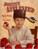
As a child, it is very rare that one does not learn about the legend of Johnny Appleseed.  Whether its through a poem, song, or cartoon, this famous figure holds the spirit of American culture.  Jane Yolen’s book, Johnny Appleseed: The Legend and the Truth, captures both the important aspects of the stories of Johnny Appleseed and the man behind the legend. There are many books about Johnny Appleseed, however Yolen’s book is unlike any other.  Through the combination of both her text and Jim Burke’s painted illustrations this book combines both the fact and fiction behind the life of Johnny Appleseed.  On each page, Yolen presents two sides of Johnny Appleseed, a poem, and also the history of his life, told as a story.  She also adds a fact at the bottom of the page to extend learning even farther, often including the source of the information.  Burke’s accompanying paintings bring more understanding to both the poem and history.  The book begins with the birth of John Chapman, who later gains the name Johnny Appleseed.

Apple blossoms
Tap the sill,
Welcome baby
With a will,
Johnny, Johnny Appleseed.

Johnny Appleseed becomes very close to his sister Lizzie as lives with his grandparents after his mother dies.  His father, Nathaniel, is a minutemen under General George Washington.  After much suffering throughout the war, Johnny and his family are very poor.  Their luck changes however, as Nathaniel returns to war and marries a new woman.  Together the two make one large family.  Johnny soon becomes very interested in nature and studies all of its parts.  As a boy in a poor family however, he cannot finish school and is hired to work under a local farm in apple orchards.

Apples are the perfect fruit.  They can be eaten fresh or be dried, put in pies or made into sauce, apple butter, cider, or vinegar, or even fermented into an alcoholic drink.  No other fruit is so useful.

In his twenties, he becomes a great follower of religion, and vows to spread his love of religion around the nation- and apples too!  He plants apples throughout his travels through Pennsylvania, Ohio, and Indiana, making friends with the native people along the way.  At his death in 1845, Johnny Appleseed owned eight hundred acres, full of apple trees!

Curriculum Connections
Johnny Appleseed is often a historical figure that is taught during early elementary school.  His lovable character and interesting story easily makes students fascinated by his story.  Johnny Appleseed, The Legend and the Truth is a great book to teach about past events through legends, stories, and historical accounts (VA K.1).  Students can also learn about Johnny Appleseed’s contribution to America through this story.  This book can easily be related to other lessons, especially with the emphasis on legends, apples, and early Americans.

Additional Resources

  •  Celebrate the birthday of Johnny Appleseed!  Use this site for a day full of activities that commemorate Johnny Appleseed and his love for apples.  Ideas include apple recipes, additional books on Johnny Appleseed, and crafts that use apples.
  • Visit to an Apple Orchard describes the experience of visiting an apple orchard.  Use this template to encourage your student to imagine the sight, sounds, smells, and touch of an apple orchard.
  • Visit An Apple for the Teacher for lesson plans involving Johnny Appleseed and apples.  Lessons cover subjects such as nutrition, language arts, history, math, and science!

Book: Johnny Appleseed: The Legend and the Truth 
Author: 
Jane Yolen
Illustrator:
 Jim Burke
Publisher: 
Harper Collins 
Publication Date: 
2008
Pages: 
32 pages
Grades: 
K-3
ISBN: 0060591358

Posted in biography, book review, history, social studies | Comments Off on Teaching History with Children’s Literature: Johnny Appleseed: The Legend and the Truth

Teaching History with Children’s Literature: Ms. Frizzle’s Adventures Imperial China

bht107l01.jpg

Have you ever thought about how much students would learn if they could go back in time to visit the countries and civilizations that they are studying in history? The book, Ms. Frizzle’s Adventures: Imperial China, written by Joanna Cole and illustrated by Bruce Degen, takes readers on an adventure to ancient China during a Chinese New Year celebration over 1,000 years ago and explains lots of information about ancient China and Chinese culture along the way.

When the story begins, Ms. Frizzle and two of her students, Wanda and Arnold, are celebrating the Chinese New Year at a local Chinatown festival. As a parade passes by, Wanda, Arnold, and Ms. Frizzle duck under the dancing dragon. When they peek out from under the dragon, they discover that they are no longer in Chinatown and have traveled back in time to visit a farmers’ village in China. The villagers there are also celebrating the Chinese New Year.

We were under the dragon for a long time. When the dragon came to a stop, we peeked out. Chinatown was gone! We were in a farmers’ village in China, and it was one thousand years ago! 

While in ancient China, Ms. Frizzle and her students dine with the farmers and help work in their rice fields. They learn all about growing rice and also discover that this year’s rice crop has been very small and as a result, the farmers cannot afford to pay all their taxes. Ms. Frizzle’s group decides to travel to the capital city to talk to the Emperor and tell him to lower the taxes. On their way to the Emperor’s palace, Ms. Frizzle and her students meet the Chinese poet Su Shi who teaches them about Chinese writing, visit a town market and learn how silk is made, and watch a battle between Chinese soldiers and an invading army at the Great Wall of China. Finally, they arrive at the capital city and find the Emperor’s palace. They then return home by walking through an “amazing door” that takes them directly into Wanda’s living room, just in time for her family’s New Year’s banquet.

Curriculum Connections
Ms. Frizzle’s Adventures: Imperial China would be an excellent book to use as part of a history lesson on ancient China. This book provides lots of information about ancient China and Chinese culture and brings the history of China to life in a memorable and educational way.

In addition to describing Ms. Frizzle’s journey through China, sections at the bottom of each page tell about many ancient Chinese inventions that are still used today, including kites, umbrellas, the compass, paper, gunpowder, and fireworks. They also show how rice is grown and how silk is made, describe the meaning of several Chinese symbols, and provide additional information about the 15-day Chinese New Year celebration.

In Virginia, this book relates to social studies SOLs 2.1 and 2.4, which state that students will explain how the contributions of ancient China have influenced the present world in terms of inventions and written language and will understand the relationship between the environment and the culture of ancient China.

Additional Resources

  • Here is a link to a Chinese New Year lesson plan. This lesson includes 4 hands-on activities that allow students to experience traditional Chinese activities, including the dragon dance and making red envelopes as a symbol of good fortune. There is also a section with background information regarding these traditions and their symbolism in Chinese culture.
  • This China webquest was designed for second graders and includes links to information about names in Chinese, Chinese writing, the Great Wall of China, and the Chinese calendar, as well as a student activity sheet for students to complete while doing the webquest.
  • This ABCs of China unit contains seventeen different lessons related to China’s geography, holidays, inventions, daily life, language, and customs.

Book: Ms. Frizzle’s Adventures: Imperial China
Author: Joanna Cole
Illustrator: Bruce Degen
Publisher: Scholastic Press
Publication Date: 2005
Pages: 40 pages
Grades: 1-3
ISBN: 0-590-10822-0

Posted in book review, history, social studies | Comments Off on Teaching History with Children’s Literature: Ms. Frizzle’s Adventures Imperial China

Teaching History with Children’s Literature: Joe and the Skyscraper

skyscraper.jpg

Joe and the Skyscraper is the story of a little boy named, Joe Carbonelli, who guides the reader around the New York City and through different eras.  The character Joe focuses on the construction of the Empire State Building in New York.  Joe gave in-depth details about the construction process of the Empire State Building.  "The rivet was then pressed firmly from both sides with a pneumatic hammer (12)."  The book goes through several significant events that take place during the construction process.  Readers will also learn about the fascination that America had with skyscrapers during this moment in history.  The book mentions that men of different ages, ethnicity, and races worked on the gigantic structure.  At the end of the book, the last two pages compare the most famous structures around the world.  This gives the reader a visual of the size of the Empire State Building and other structures in the United States compared to those in other countries.

Dietrich Neumann does a great comparing the different shapes, sizes, and cultures that go into all of the architecture in New York City.  He uses photos of different landmarks throughout the city and a witty character named Joe to grab the attention of the reader.  The book goes from landmarks built in the early 1900s to more modern buildings in New York City. The history in this book really analyzes the culture behind the architecture.

Curriculum Connections
The student will learn about the history of architecture in New York City.  The students will be able to discuss the different tactics and significant instruments used to create a significant structure.  This book correlates directly with History SOLs 2.3.

Additional Activities

  • Try spelling with the Empire State Building and your students.
  • Try playing Jenga with your students and make the tower as tall as possible.

Book: Joe and the Skyscraper
Author/Illustrator: Dietrich Neumann
Publisher: Prestel Publishing
Publication Date: 1999
Pages: 28 pages
Grades: 3-5
ISBN: 379132103

Posted in book review, history, nonfiction | Comments Off on Teaching History with Children’s Literature: Joe and the Skyscraper

Teaching Geography With Children’s Literature: We’re Sailing Down the Nile

sailingdownthenile.jpg

From visiting temples, to marketplaces, to museum halls to  Giza’s pyramids the book We’re Sailing Down the Nile is a journey your class will not forget! Laurie Krebs seamlessly meshes rhyming and informative text with Anne Wilson’s vibrant illustrations. The book starts off on a river boat that is traveling down the Nile River. The adventure takes the children to seven notable locations in Egypt along the Nile River. They stop at Abu Simbel’s monuments, Aswan, Kitchener’s Island, the Valley of the Kings’ tomb, Al-Faiyum Oasis, Egypt’s capital Cairo and end at The Great Pyramid of Giza.

Kreb’s writes the text repeating the phrase “Climb aboard the river boat! We’re sailing down the Nile. We’ll visit Abu Simbel in just a while (Page 2)” and substitutes in a new location every time it changes. This repetition makes the book easy to follow for students and the rhyming help captivate your students’ interest. The book provides simple wording of the text so children can easily understand it and even read it independently. Extra footnotes provide explanation to terms that children or teachers alike might need extra support on:

Kalila guides us to the souk *(marketplace). We buy some food to share. We’ll picnic on the Island (*Kitchner’s Island) with the others gathered there (Page 7-8).

One of the most impressive aspects about the book is the additional support given at the conclusion of the book. It gives a map and description of the journey, history of Ancient Egypt and a lot more helpful background information relating to Egypt. If you are looking for a great read-a-loud book to introduce your class to the geography and history of ancient Egypt this is it!

Curriculum Connections
We’re Sailing Down the Nile
is a great book to introduce geography and the culture of Egypt to your class. The cross-curricular extensions are also impressive as you could incorporate in story writing or a math lesson comparing different country sizes. It could also be used to develop student’s map skills with world maps. In Virginia this book would be suitable to fulfill the Geography Standard of Learning 2.4 a and b, which involves map skills and understanding the culture and environment of ancient Egypt.

Additional Resources

Book: We’re Sailing Down the Nile
Author: Laurie Krebs
Illustrator: Anne Wilson
Publisher: Barefoot Books
Publication Date: 2007
Pages: 40 pages
Grades: 2-3
ISBN: 1846860407

Posted in book review, geography, social studies | Comments Off on Teaching Geography With Children’s Literature: We’re Sailing Down the Nile

Teaching Geography with Children’s Literature: Shall I Knit You a Hat?

Aspects of geography affect our lives every day.  It is likely that each day we get up and use the weather report to decide what to wear.  We may also base our decisions on what to eat and what kind of transportation we rely on due to our location and its climate.  For example, if it’s snowy, many people prefer hot chocolate to ice cold soda for refreshments. When vacationing in Alaska, most would rather stay in a warm lodge than a bamboo hut.  Kate Klise presents a similar theme in her story Shall I Knit You a Hat?

Klise’s Shall I Knit You a Hat? is a story that describes the importance of making decisions based on the way people live in their environment.  This story follows Mother Rabbit and Little Rabbit as they prepare for a blizzard that is coming on Christmas Eve.

 “It will start snowing on Christmas Eve and won’t stop until the snow reaches the tallest tips of your ears.”
“My ears?” asked Little Rabbit. “But that will be very cold.”
“You’re right, ” said Mother Rabbit. “Shall I knit you a hat to keep your ears warm?”

To ensure Little Rabbit will be secure in the storm, Mother Rabbit knits a hat that will perfectly fit Little Rabbit’s tall ears. Because Little Rabbit enjoys his hat so much, he suggests that he and his mother make more hats to help keep his friends warm too.  They visit the horse, the goose with the long neck, the stylish cat, the dog, and the deer with antlers to make measurements for their hat.  Little Rabbit and his mother stay up all night knitting and sewing each individual hat.  The next day, they decide to use a sled to deliver their presents in the market due to snow on the ground.  Just as they hand out the hats, snowflakes begin to fall from the sky!  Luckily, all the friends have their new hats for the weather!

 Just look how this clever hat keeps my head warm and dry,” said the horse.

Curriculum Connections
Shall I Knit You a Hat?
is a great book to introduce how location, climate, and physical surroundings affect the way people live (Virginia SOL 1.6).  The illustrations, by M. Sarah Klise, also serve as a great tool for teaching about geography. The scenery describes the location, displaying tall hills, full of snow with many snowflakes falling down. Due to the climate and the presence of snow, the main characters are shown dressed in warm hats.  Little Rabbit and Mother Rabbit also choose to use a sled as their form of transportation in the story.  Through these examples, it is clear their daily lives are affected by their location and climate.  It may be interesting to read another story that compares this winter setting to a warmer one and discuss how the clothing, forms of transportation, and weather are different in the stories

Additional Resources

  • For more books written by Kate Klise and illustrated by M. Sarah Klise, check out their website!
  • The Crayola website offers a great sewing craft that emphasizes the use of sewing in Shall I Knit You a Hat?  This activity, Love You ‘Sew’ Much Cards, also stresses the significance of gift giving.
  • Use this geography lesson plan to teach about Africa and how the weather affects the people who live there.  This lesson encourages students to question how geography affects their lives as well.

Book: Shall I Knit You a Hat? 
Author: 
Kate Klise
Illustrator: M. Sarah Klise
Publisher: Henry Holt and Co. 
Publication Date:
2004
Pages: 32 pages
Grades: 
K-3
ISBN:
 
0805073183

Posted in book review, geography, social studies | Comments Off on Teaching Geography with Children’s Literature: Shall I Knit You a Hat?

Teaching Geography With Children’s Literature: Celebrate the 50 States!

 states.jpg

Have you ever been curious to know specific interesting facts of all 50 states! What makes each state unique and different from each other? Loreen Leedy provides tons of information on each of the fifty states in her book entitled Celebrate the 50 states! Leedy explains each of the fifty states in the same structure.  She uses half of a page that contains the state’s name, a representation of what the state looks like on a map with some key cities, the state bird and flower, scale of the map, ocean or lake and rivers, products from each state as well as other interesting facts about each of the states.  Here is an example.

Virginia: The first successful English colony was founded in Jamestown, Virginia, in 1607.

Visitors come to Williamsburg to see how the colonists lived.

Illustrations include a dogwood, cardinal, ham, and some Jamestown artifacts. There is also a map of Virginia with some key cities (Richmond, Alexandra, and Norfolk).

Each of the state also includes information on the year it entered the Union and the state rank.  In addition, Leedy asks questions about each of the states.  To stay with our Virginia example, the question that is asked is “George Washington is known as the father of our country.  Why is Virginia nicknamed “Mother of Presidents”?  At the end of the book there is an answer key with all of the answers that children can flip back to.  If you were all wondering, Virginia is nicknamed the “Mother of Presidents” because eight presidents were born there, including Washington.  The last two pages of the book before the answer section include a full map of the United States with each of the states labeled so children can see the “big picture” and how all the states look in relation to each other.  This book is a great way to get children excited about learning all the states and the corresponding facts.  The illustrations are colorful and fun to look at.  In addition, Leedy includes interesting information that children would want to know as well as teaching about general geography information, such as reading maps and locating waterways and key natural resources or products each state makes.  

Curriculum Connections
This book offers a great way to introduce the study of the fifty states. Specifically in Virginia it can be used to locate the 50 states and cities most significant to the historical development of the United States as well as locating and describing the location of geographic regions as well as water features in the United States (Social Studies Standards of Learning USI.2 and USII.2). This book can also be used in studying basic elements of geography. For instance understanding basic map skills, learning map symbols, and describing how the location of a community, climate, and physical surroundings affect the way people live, including their food, shelter, transportation and recreation (SOL 1.4).

Additional Resources

  • This website is a great resource for teachers and kids to learn more about each of the states.
  • Here is a map students can print out and fill in of the fifty states!

Book: Celebrate the 50 States!
Author:
Loreen Leedy
Publisher:
Holiday House
Publication Date: 1999
Pages:
32 pages
Grades:
1-5
ISBN: 0823414310

Posted in book review, geography, social studies | Comments Off on Teaching Geography With Children’s Literature: Celebrate the 50 States!

Teaching Geography with Children’s Literature: This Is the Way We Go to School

 school.jpg

How do children around the world get to school everyday?  How do these means of transportation differ from the way you get to school?

This is The Way We Go To School, by Edith Baer, depicts the different regions of the globe by the way that the children who live in these regions make their way to their schools every day. These different means of transport reflect the regional climates and physical features of the environment. Some children walk, some take the trolley, while others go by boat or skis.

And the famous Metro line suits Igor and Ilyana just fine. Go by Copter? By Skidoo? Somewhere, sometimes, some kids do.

Not only does the book explore different regions of the world and ways that people get around in these places, it also explores different cultures of the regions. The children who are presented have  names that are common in the areas that they live. Illustrations of children show them performing acts that may help students learn some of what life may be like for students that live in these countries. At the end there is a page that tells which country each child lives in. On the last page there is a map for students to connect the country with its proper place on the map, providing a greater image of where students are in the world and how far or near they are geographically to the students they have just read about.

Curriculum Connections
This book could be used to show students  a simple map where they can describe places referenced in stories and real-life situations(K.4). It could also be used to describe the location of his/her community, climate, and physical surroundings and the way they affect the way people live, including their transportation.(1.6)

Additional Resources

Book: This is the Way We Go To School
Author:  Edith Baer
Illustrator: Steve Bjorkman
Publisher: Scholastic
Publication Date: 1990
Pages: 35
Grades: K-2
ISBN: 0-590-43162-5

Posted in book review, geography, social studies | Comments Off on Teaching Geography with Children’s Literature: This Is the Way We Go to School

Teaching Geography with Children’s Literature: How I Learned Geography

shulevitzlearn.jpg

Students learn best through lived or shared experiences. In How I learned Geography, Uri Shulevitz shares his first time learning about geography.

The story begins with the Uri having to leave his home and belongs because of a devastating war.  He and his family are forced to leave and travel very far to a land where the houses are made of clay, straw, and camel dung. Uri lived in house with another couple he did not know.  Food was extremely scarce. One day Uri father went to the bazaar to buy bread.  When his father returned he announced,

“I bought a map!”

Uri was very frustrated that he would have to go to sleep hungry.  The next day his father hung the map on the entire wall.  His fascination grew for the detailed drawings and the exotic names.  He would draw and make rhymes.  As repeated the names he was transported to the burning deserts, sanding beaches, and snowy mountains.  He saw temples with stone carvings animals of different colors.  Uri explored all types of lands and ate papayas and mangoes as he pleased.

He was learning so much about the world, things he would have never known about if it was not for the map. This map preoccupied him from his hungry and misery.  He eventually forgave his father because he saw he was right.

Curriculum Connections
How I learned Geography would serve as a great closer to a lesson about maps. This is a great tool for teacher to use when they want students to have an awareness that maps and globes show a view from above and in a smaller size this correlates to Virginia sol k.5 a,b .

Additional Information

  • Story Maps is an activity from National Geographic which allows students create a map from a favorite class book.
  • Map Skills is a lesson provides students with the opportunity to make a map of their school. Students then compare and contrast their perception of the school to their classmates perception.
  • Memorable Maps is a great lesson in which students draw a world map from memory. Nine months later they are then told to draw the world map and see how the picture has improved.

Book: How I Learned Geography
Author/Illustrator:
Uri Shulevitz
Publisher: Farrar, Straus and Giroux
Publication Date:
2008
Pages:
32 pages
Grade:
K-5
ISBN:
978-0374334994

Posted in book review, geography, social studies | Comments Off on Teaching Geography with Children’s Literature: How I Learned Geography

Teaching Geography with Children’s Literature: Atlantic

30866352.jpg

What brings warm weather to Ireland?  It’s the same thing that brings dry winds to Africa— The Atlantic Ocean, of course!  Atlantic, written and illustrated by G. Brian Karas, provides a wonderful introduction of world geography to children.  The story, narrated by the Atlantic Ocean, poetically explains:

I stretch from the icy poles,
North and South
I rub shoulders with North America
and bump into Africa
I slosh around South America and crash into Europe

Karas effectively explains some of Earth’s processes through illustrations and verse,

The moon
so far out in space
pulls at me
and then lets go
so my tides go in and out,
ebb and flood

Atlantic explains how the oceans have been around long before people named them, charted and studied them, and dirtied them.

Curriculum Connections
Atlantic is a great book to use when teaching geography.  This book includes facts about the Atlantic Ocean, including its relationship to other oceans and earth’s land masses.  With an emphasis on human and environment interaction, students are provided with a big-picture overview of the world.

In Virginia,  Atlantic can be used to teach social studies SOLs K.4 and 3.5, which state that students will locate land and water features and develop map skills by positioning and labeling the seven continents and four oceans to create a world map.

Additional Resources

  • This World Atlas is an interactive site which provides maps and information about every continent, ocean, and region.  It can also can be used on a micro level, providing detailed maps and information about every country and each state in the United States.  It is also available in Spanish.
  • This site, powered by Enchanted Learning, provides information about the oceans and processes that involve the oceans, such as the water cycle, tides, and waves.
  • Here is a lesson plan about the states on the east coast of the United States and their relationship to the Atlantic Ocean

Book: Atlantic
Author / Illustrator: G. Brian Karas
Publisher: G.P. Putnam’s Sons
Publication Date: 2002
Pages: 29
Grades: K-3
ISBN: 0-399-23632-5

Posted in book review, geography, social studies | Comments Off on Teaching Geography with Children’s Literature: Atlantic

Teaching Geography with Children’s Literature: There’s a Map on My Lap

maplap.jpg

Tish Rabe uses Dr. Seuss’s age old character The Cat in the Hat to teach about maps, reading maps and anything about a map that students will want and need to know in There’s a Map on My Lap. The story is written in true Seuss-fashion with a flowing rhyme scheme and comparisons that will help children understand difficulties such as the distortion a globe makes or how a scale works. Rabe introduces how a map looks taken of a globe by comparing it to an orange.

Peel the skin off an orange
and lay it out flat.
A flat map of the earth
will look something like that.

Rabe introduces and explains topics such as scale, direction, map making, latitude and longitude, legends, paths and puzzles. Almost every page has an information square that explains the term the Car uses in his rhymes and asks questions that can easily be posed to the class. Illustrator Aristides Ruiz uses old fashion cartoon drawings that replicate the Seuss-age drawings to make the book very fantastical, colorful, yet strangely understandable and realistic. The terms are clearly illustrated and explain the words on the page and each different place the Cat goes displays a new map of what the city, sea or bedroom map (or plan) may look like.

Curriculum Connections
There’s a Map on My Lap
uses all aspects of geography and may making to explain concepts such as legends, direction, population, and and scale. Each different topic is a couple of pages long and goes into detail about how to make a scale for a map, how to remember coordinate directions and several pages of the United States and the different state lines. There are multiple pages on many different aspects of geography that can be used in separate lessons (topics include: longitude, latitude, scale, directions, legends, coordinates, various types of maps, population density, different routes to take, measurement using string, and the United States). In Virginia, these topics correspond to SOLs K.4, K.5, 1.4, 1.5 and 2.6.

Additional Resources

  • Introduction to Maps is a website about that includes reading maps, map information and reproducibles about maps.
  • Pedagogy is website that includes a lesson plan about making maps after reading There’s a Map on My Lap!. It also includes follow up and extension activities using map vocabulary.
  • There’s a Map on My Lap is a Word document that includes geography information, websites, and additional resources for students in grades K-6.

Book: There’s a Map on My Lap
Author/Illustrator:
Tish Rabe
Publisher: Random House
Publication Date:
2002
Pages:
48 pages
Grades:
K-3
ISBN:
0375810994

Posted in book review, geography, social studies | Comments Off on Teaching Geography with Children’s Literature: There’s a Map on My Lap