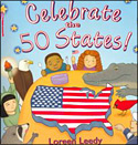
Have you ever been curious to know specific interesting facts of all 50 states! What makes each state unique and different from each other? Loreen Leedy provides tons of information on each of the fifty states in her book entitled Celebrate the 50 states! Leedy explains each of the fifty states in the same structure. She uses half of a page that contains the state’s name, a representation of what the state looks like on a map with some key cities, the state bird and flower, scale of the map, ocean or lake and rivers, products from each state as well as other interesting facts about each of the states. Here is an example.
Virginia: The first successful English colony was founded in Jamestown, Virginia, in 1607.
Visitors come to Williamsburg to see how the colonists lived.
Illustrations include a dogwood, cardinal, ham, and some Jamestown artifacts. There is also a map of Virginia with some key cities (Richmond, Alexandra, and Norfolk).
Each of the state also includes information on the year it entered the Union and the state rank. In addition, Leedy asks questions about each of the states. To stay with our Virginia example, the question that is asked is “George Washington is known as the father of our country. Why is Virginia nicknamed “Mother of Presidents”? At the end of the book there is an answer key with all of the answers that children can flip back to. If you were all wondering, Virginia is nicknamed the “Mother of Presidents” because eight presidents were born there, including Washington. The last two pages of the book before the answer section include a full map of the United States with each of the states labeled so children can see the “big picture” and how all the states look in relation to each other. This book is a great way to get children excited about learning all the states and the corresponding facts. The illustrations are colorful and fun to look at. In addition, Leedy includes interesting information that children would want to know as well as teaching about general geography information, such as reading maps and locating waterways and key natural resources or products each state makes.
Curriculum Connections
This book offers a great way to introduce the study of the fifty states. Specifically in Virginia it can be used to locate the 50 states and cities most significant to the historical development of the United States as well as locating and describing the location of geographic regions as well as water features in the United States (Social Studies Standards of Learning USI.2 and USII.2). This book can also be used in studying basic elements of geography. For instance understanding basic map skills, learning map symbols, and describing how the location of a community, climate, and physical surroundings affect the way people live, including their food, shelter, transportation and recreation (SOL 1.4).
Additional Resources
- This website is a great resource for teachers and kids to learn more about each of the states.
- Here is a map students can print out and fill in of the fifty states!
Book: Celebrate the 50 States!
Author: Loreen Leedy
Publisher: Holiday House
Publication Date: 1999
Pages: 32 pages
Grades: 1-5
ISBN: 0823414310