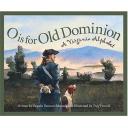
O is for Old Dominion, written by Pamela Duncan Edwards, is a wonderful children’s story that outlines major historical figures and historical sites across the state of Virginia. The story also highlights other aspects of the state such as beaches, universities, cities, and natural resources. Each page of this story contains a short, rhyming text in the middle of the page as well as a longer text that goes into more detail on the outside of each page. O is for Old Dominion is beautifully illustrated by Troy Howell and each of his illustrations appropriately depicts the alphabet letter described on the page. At the end of the story there is a fifteen question quiz about Virginia facts from the story.
- “E is for the Emanicpation Oak where they read out Lincoln’s law, saying slaves and their descendents could walk through freedom’s door.” (pg. 6)
- “R is for John Rolfe, who made Pocahontas his wife. She changed her name to Rebecca and enjoyed colonial life.” (pg. 24)
- “Which military general had to choose whether to lead the North or the South in the Civil War? Which side did he eventually lead?” (pg. 35)
Curriculum Connections:
O is for Old Dominion is a great way to introduce students to a unit on the state of Virginia and it’s history. The story defines the civil war, military and government leaders in Virginia history, geographical regions of Virginia and colonial sites in Virginia. Pamela Duncan Edwards makes great connections with the Virginia state SOLs VS.2, VS.3, and VS.10 in Virginia Studies which have students demonstrate knowledge of physical geography and native peoples both past and present, demonstrate knowledge of the first permanent English settlement in America and demonstrate knowledge of government, geography, and economics.
Additional Resources:
- These activities engage the students in the ways the Powhatan indians survived: fishing, farming, and hunting. Students are taught that almost everything these indians did revolved around nature.
- This lesson plan allows students to locate the state of Virginia on a map, as well as the capital, and their hometown. Students will also observe pictures of the city of Richmond and learn about the governor of the state.
- This map- making procedure highlights the four regions of Virginia and has the students outline each region on their own map. They are: Tidewater, Piedmont, Ridge and Valley, and Appalachian Plateau.
General Information:
Book: O is for Old Dominion
Author: Pamela Duncan Edwards
Illustrator: Troy Howell
Publisher: Sleeping Bear Press
Publication Date: September 2005
Pages: 40
Grade Range: K- 3
ISBN: 9781585361618