Final Project: My Costa Rica Storymap
Posted in Assignment 10, Assignment 9
Comments Off on Final Project: My Costa Rica Storymap
Joy and Marissa’s Blunder Map

Blunders:
- Switched Crenshaw Way and Keller Road labels.
- Switched UR Drive and College Road labels.
- Added toxic symbol to lake.
- Added dollar sign to location of future Queally Hall.
- Tilted North arrow.
- Changed scale bar unit to meters.
Posted in Assignment 8
Comments Off on Joy and Marissa’s Blunder Map
Project Progress Map (Marissa Parker)
Posted in Assignment 5
Comments Off on Project Progress Map (Marissa Parker)
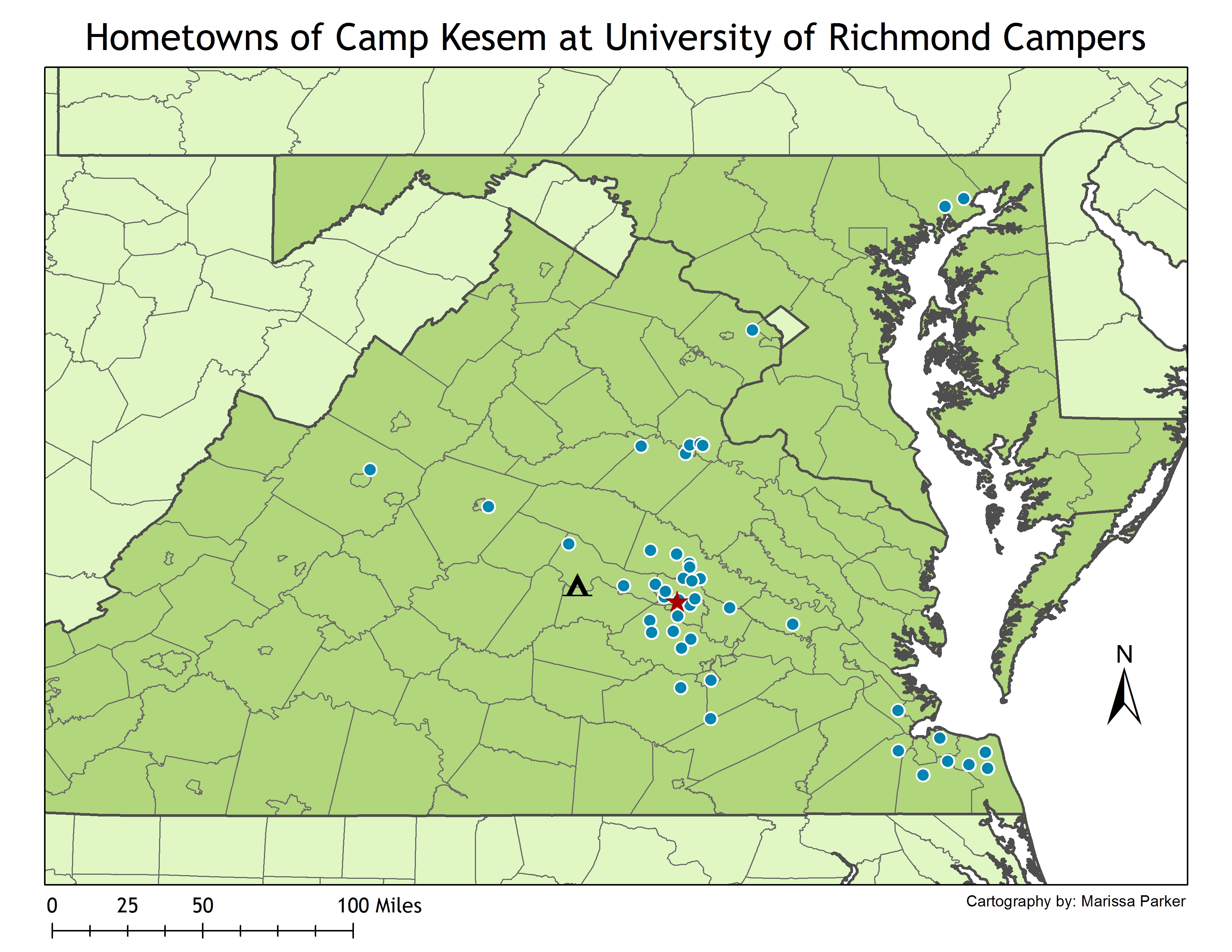
Project #1 Plan
For my first project, I want to create a map showing the geographic distribution of the campers at the University of Richmond chapter of Camp Kesem. As a Development Coordinator for Camp Kesem at University of Richmond, I’m interested to know where our campers come from across Virginia when writing geographic-specific grant applications. I already have the addresses of all of our campers from last August and tested the geocoding feature on ArcGIS, so this project would entail editing the cartographic features to create a visually appealing map. The extent would be all of Virginia and part of Maryland and each camper family would be represented by one dot (even though most families have more than one camper). I also plan to add points for the University of Richmond campus as well as for our campground, Westview on the James, in Goochland.
Edits:
I will either make sure not to use any names in my data tables or I will use the centroid of the zipcode in order to ensure privacy.
This map’s audience will include all Camp Kesem at University of Richmond student leaders. This map can also be replicated by all other Camp Kesem chapters for them to use in the same way, but with their own camper data.
Posted in Assignment 4
Comments Off on Project #1 Plan
Swiss Cheese Map Article Reflection
I really enjoyed reading this article by one of Richmond’s own professors. The first page or so was difficult to comb through since I have no background knowledge on the Oslo II peace talks or about this area of Israel. However, once Motro starting talking about the significance of the maps used in the negotiations, I found the material very interesting. Motro’s explanation of the series of maps created after the peace talks also provided a lot of historical perspective. Her explanation of the significance of using different shades of the same hue for present countries and future territories was particularly interesting. Overall, I thought this was a great article, especially because it was written by someone who isn’t necessarily a cartographer by trade.
Posted in Assignment 3
Comments Off on Swiss Cheese Map Article Reflection
Web Mapping Products
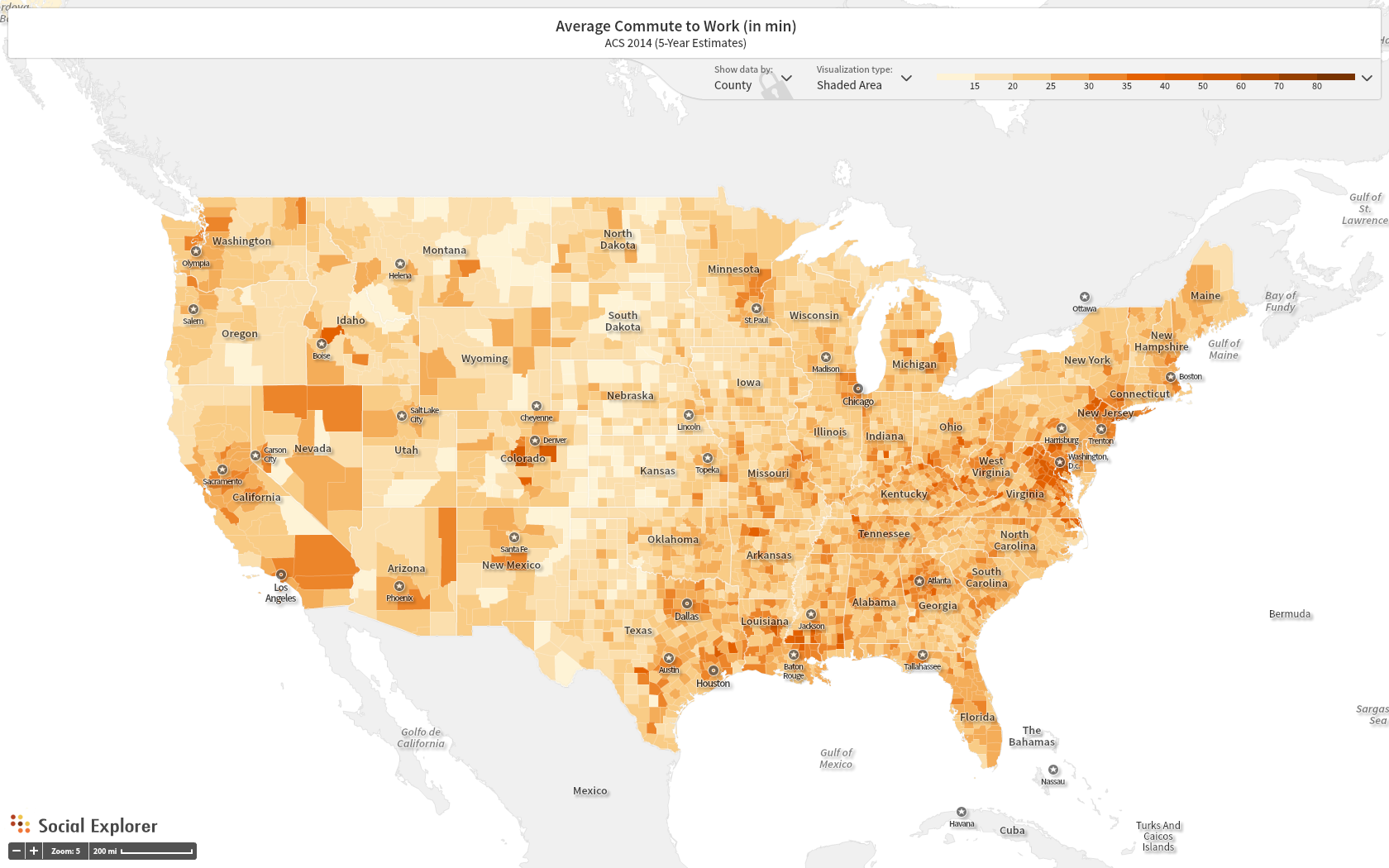
Map 1: Average Commute to Work in US by County (2014). Created in Social Explorer.
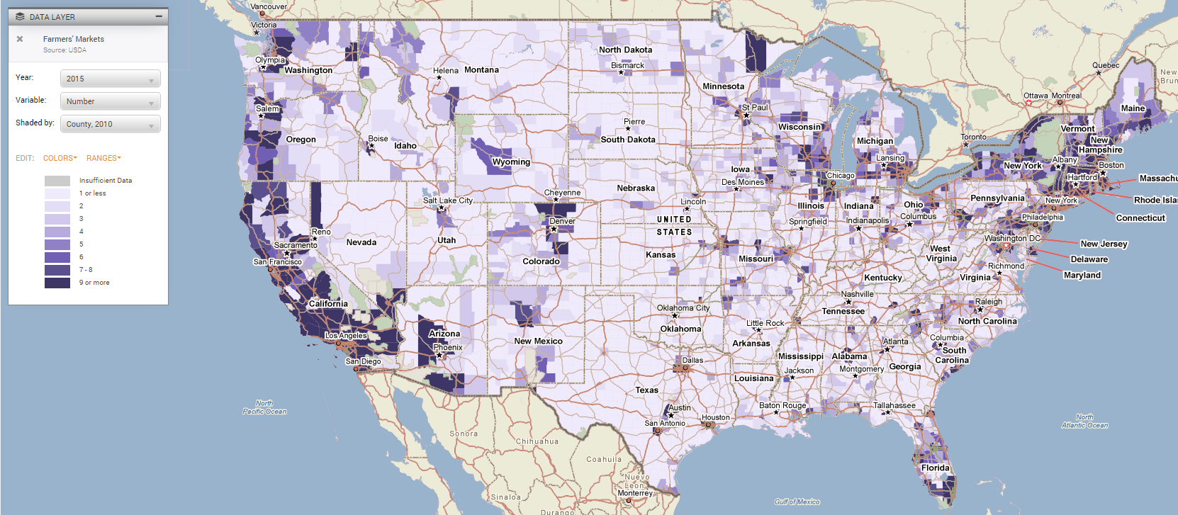
Map 2: Number of Farmer’s Markets in US by County (2015). Created in PolicyMap.
Posted in Assignment 2
Comments Off on Web Mapping Products
Why Maps & Geovisualizations?
In this course, I hope to expand my geospatial skills and learn new visualization technology. In my introductory GIS class, we touched upon cartography principles and map making. But we only made maps in ArcMap which has very limited functionality and is not the best for making “pretty” or dynamic maps. I’ve also picked up some skills and tools in map making throughout my other geospatial experience. However, I think I still have a lot to learn and that I want to learn in geovisualizations which is why I decided to take this class. In the past, I have taken introductory GIS and Advanced Spatial Analysis and spent a summer interning in the Spatial Analysis Lab. This semester I am taking Advanced Spatial Analysis again and still serving as a SAL intern.
In this course, I hope to learn more about CartoDB as a geovisualization program. I also hope to gain more exposure about visualization possibilities. I have learned about some helpful map making tools such as Data Driven Pages in ArcGIS. I have a little bit of experience with CartoDB, but I know these is a lot more to learn and I can gain a lot more experience. I hope this class overall helps expand my geospatial experience and repertoire to help me in my future career endeavors.
Posted in Assignment 1
Comments Off on Why Maps & Geovisualizations?
Hello world!
Welcome to blog.richmond.edu. This is your first post. Edit or delete it, then start blogging!
Posted in Uncategorized
Comments Off on Hello world!