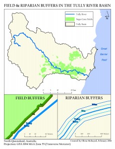
I will be updating the map titled: Riparian Buffers in the Tully River Basin. In order to improve this map I will improve the symbology of the map by simplifying fills, making fills the appropriate colors, and considering the weight and depth of each line. I will label areas and make a small reference map to illustrate the location of this basin in Australia or in the general region. I will improve general formatting to remove useless white areas and make the map area large and easy to understand. If I do inset maps I will add scales to them as well. I will also double check to make sure the chosen map projection is suitable.
Update:
Here’s what I have so far, let me know what you all think!
