The concepts of power, space, and territory are pervasive and influential factors that unavoidably play a major role in the realization of any sort of tangible map of a particular region. The relationship between people and their environment is one that is tightly bound, and it has been generally accepted that people’s conceptualization of nature and geography is born of our own imposed organization and social interpretation of our surroundings (Perreault 98).
This idea plays a central role when it comes to the creation of maps and the conceptualization of formalized borders and the division of a given space into recognized territories. As such, the borders created may be seen and interpreted differently according to the varied perspectives of the groups involved in the area, especially if communication between them is lacking, as can be seen in the attempted mapping of conserved spaces. Bjorn Sletto writes that formulating any border in a region is an inherently political act with far-reaching consequences and multiple voices being consulted:
“Boundary making for purposes of conservation management within these once marginal spaces has now become a politicized process involving not only the state and substate actors, but also international and global institutions. ” (Sletto 189)
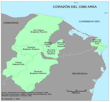
In the case of the Corazón Transboundary Biosphere Reserve, the high volume of these groups and organizations that are involved in the project, including both the Honduran and Nicaraguan governments, NGO’s such as UNEP, international institutions including the World Bank, as well as indigenous inhabitants, has made mapping the Corazón region and producing one uniformly accepted boundary a particularly ambitious task. The incoherence of the boundaries is extremely evident in the maps produced by the separate organizations involved. While most maps focus on the same general region, several discrepancies can be observed surrounding which pre-existing Biosphere Reserve are considered to be part of the Corazón Protected Area, and which are still considered separate projects.
When evaluating these problems, factors such as a miscommunication, over-simplification, and misrepresentation can all be pointed to as major sources of the discrepancies observed between the maps. For an in- depth explanation of the intertwined roles of miscommuncation, misrepresentation, and oversimplification, click here.
UNEP Map of the Corazón Biosphere Reserve Project:
—————————————————————————
CCAD Maps of the Corazón Biosphere Reserve Project:
CCAD Map #1:

Map courtesy of Comision Centroamericana de Ambiente y Desarollo, 2006
CCAD Map #2:

Map courtesy of the Sistema de Información Ambiental Mesoamericano, 2005
—————————————————————————
Discrepancies can be found in which areas are considered buffer zones and which are part of the actual conservation region, as well as the expansiveness of the borders on the Nicaraguan side of the biosphere, and the level of contiguity of the pre-existing biospheres.
Although they are individually concerning, these three processes of miscommunication, misrepresentation and oversimplification are deeply intertwined co-factors that frequently have the effect of propagating one another. These misunderstandings are a huge threat to the successful boundary making process in the Corazón — the ability to successfully create something as fundamental as a border is a telling factor of the level of organization, commitment and the potential for success of the overall project. As Finley-Brook and Offen investigate, these inconsistencies and misinterpretations can lead to the increased production of both contested space and neoliberal space, and have a possibility of doing more harm than good (Finley-Brook et al 348).