I am currently pursuing three related research themes: urban landscape connectivity, habitat modeling, and air and watershed assessment. The themes are related in that spatial landscape models can be used to address each. The types of questions that I address include:
- How do wildlife species and communities respond to changes in environment such as those predicted with a warming planet?
- How do organisms move across the landscape and how is this movement influenced by urban planning policies and actions? and
- How do human uses of the land alter ecosystem flows related to air and water and how effective are remediation actions in reducing these impacts?
Urban Landscape Connectivity
Habitat loss and fragmentation is thought to be the number one threat to biodiversity, worldwide. Too often, studies do not distinguish between the effects of habitat loss and the effects of strictly defined habitat fragmentation – i.e., the breaking up of habitat, independent of loss. Although the negative effects of reductions in habitat have been well documented, the direct effects of fragmentation are less well understood. My research invokes GIS-based methods of network analysis to address questions of landscape connectivity, metapopulation dynamics, and species dispersal in fragmented habitats.
In theoretical studies on randomly generated landscapes, we have shown how connectivity metrics systematically vary as a function of habitat loss. Deviations from these theoretical curves for real landscape can be used to interpret the true impact of the spatial pattern of fragmentation, controlling for the overall quantity of habitat. In other theoretical work, my lab has demonstrated that many connectivity studies may be misrepresenting the risk of exotic plant invasions for fragmented landscapes by not fully taking into account the importance of initial conditions at the time of species introduction. We have also explored general strategies for designing effective conservation networks in the United States and have tested new methods for evaluating functional connectivity.
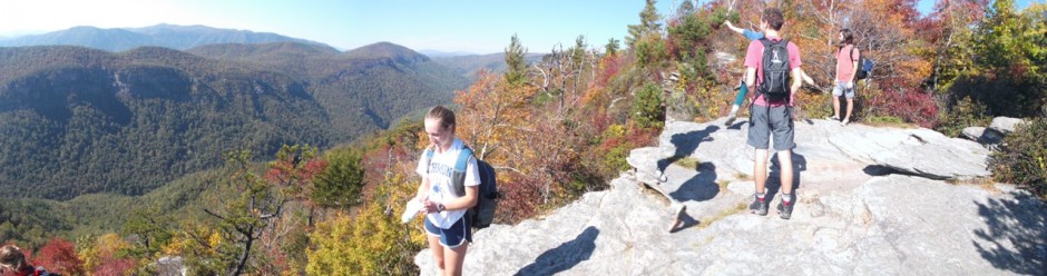
My research in this area is not organism nor location specific, but rather focuses on advancing connectivity theory and the application of that theory. In addition to invasive plants, my research in National Park landscapes is currently addressing issues of connectivity for squirrels, bats, mammals, and amphibians. My research interests with the National Park Service are generally less in the relatively pristine park units of the west and more in the mixed use parks in urban and sub-urban settings of the eastern United States. Because these parks have been managed for some time to maintain a mixture of habitat types (e.g., to preserve the conditions observed during the civil war), I argue that they are excellent mesocosms for the study of habitat fragmentation. Past student projects include an analysis of the green infrastructure network along the James River. My work with the National Parks of the National Capital Region was recognized for excellence in natural resources research. Our recent review study surveyed the state of the field of urban connectivity literature and identified general themes and future research needs.
Species Distribution Modeling
My interest in modeling the spatial distribution of species based on their habitat requirements stems from dissertation work in the Oregon Western Cascades. In this study, I examined the correlation between physical components of the environment and the spatial transition of old-growth forest types. I found that although temperature was a major correlate with community composition at the landscape level, variability in soil moisture and snowpack was more important in shaping vegetation distribution at the local level, especially for understory plants. The implications severely complicate efforts to predict how these forests may respond to climate change scenarios. As a major product of this research, I developed a series of novel sampling and analytic approaches to extrapolate fine-grain environmental variability in temperature, soil moisture, radiation, and snowpack to the larger scales typical of resource management and environmental policy. These spatially implicit models allow for ready visualization within a GIS framework. Work continues on this project with an emphasis on generating better spatial models of variability in snowpack and on identifying biological mechanisms of species turnover at the ecotone level.
More locally, our work includes examining changes in forest bird and wetland communities in the state and national parks of Virginia, Maryland, and Washington, D.C. In Richmond, we have ongoing studies of the biodiversity of rock pool aquatic communities in the James River and trees on the University of Richmond campus.
Air, Watershed, and Park Assessment
A third research interest of my lab is on the landscape controls of atmospheric and hydrologic processes. A major emphasis of this work is on exploring the relationships between temperature, air quality, socio-demographic factors, and urban planning decisions for the City of Richmond. These studies illustrate the correlation between urban heat islands and historical redlining practices that barred black and minority groups from securing homes. They also illustrate connections between temperature and air quality in Richmond – i.e., areas of extreme heat tend to be those with the worst air quality. On campus, we have created a comprehensive map of the amount of carbon stored in university trees.
Another focus of this research is on improving the scientific understanding and predictability of the relationship between human land use change and flooding. Surface mining is the dominant driver of land cover change in the central Appalachian Mountains. Reclamation, the federally mandated replacement of mining overburden to approximate original contours, has likely not resulted in restoration of pre-mining hydrology, though this has been poorly studied. Our model results for small watersheds in western Maryland indicate that changes in flood frequency and intensity induced from mine reclamation do not match those predicted from either forest harvesting or urbanization studies. More broadly, I have a strong interest in the concept of riverscapes and how society has acted to promote the increased the mobility of water, energy, materials, and organisms in urban watersheds. I have ongoing studies investigating the patterns of development within the James River and Potomac River basins and how this development affects watershed hydrology. My lab is particularly interested in the ecosystem effects of suburban and exurban development. Much of this work is conducted as community-based collaborations.
 Much of this work is also done in close collaboration with the National Park Service and their natural resource assessment programs, especially in battlefield parks. I have worked closely with the Inventory and Monitoring (I&M) program: (1) to develop and refine their monitoring protocol for remote sensing; (2) to construct ecosystem-based conceptual and quantitative models that effectively communicate monitoring principles and data through conceptual diagrams; and (3) inventory wetland resources using remote sensing and field data. In related work, I conducted gap analyses and prioritization schemes for sites in the Northeast and Southeast U.S. for potential listing as National Natural Landmarks (NNLs). We have conducted site-specific evaluations that have led to the national listing of the Nottingham Serpentine Barrens, PA, Ice Mountain, WV, Albany Pine Bush, NY, and Bear Rocks Plateau, WV as new National Natural Landmarks. All of these projects have provided excellent student research opportunities.
Natural Resource Condition Assessment Reports
Engelhardt, K., T. Lookingbill, N. Bukach, M. Latimer*, K. Ratliff, R. Gifford, J. Baek*, M.O. Hubert*, A. Rizzo, and B. Walsh. 2019. Natural Resource Condition Assessment for Harriet Tubman Underground Railroad National Historical Park. Natural Resource Report NPS/HATU/NRR—2019/1897. National Park Service, Fort Collins, Colorado.
Lookingbill, T., K. Engelhardt, C. Geraghty*, N. Hatchel, & D. Kitchen. 2018. Natural Resource Condition Assessment for Fort Monroe National Monument. Natural Resource Report NPS/FOMR/NRR—2018/1604. National Park Service, Fort Collins, Colorado.
Lookingbill, T., H. Courtenay*, J. Finn, R. Gifford, N. Hatchel, M. Mulroy*, A. Pericak*, & M. Rouch. 2017. Natural Resource Condition Assessment for Booker T. Washington National Monument. Natural Resource Report NPS/BOWA/NRR—2017/1558. National Park Service, Fort Collins, Colorado.
Costanzo, S. D., T. Lookingbill, B. Walsh, A. Fries, S. Spitzer, J. Hawkey, V. Vargas, B. Webb, S. Easby*, C. Goelst*, & M. Rouch. 2016. Natural Resource Condition Assessment for Shenandoah National Park. Prepared for Natural Resources Condition Assessment Program, NPS. Natural Resource Report. NPS/SHEN/NRR—2016/1190. National Park Service, Fort Collins, CO.
Lookingbill, T., B. Miller*, J. Madron, J. Finn, & A. Valenski*. 2013. Natural Resource Condition Assessment for Petersburg National Battlefield. Prepared for Natural Resources Condition Assessment Program, NPS. Natural Resource Report. NPS/PETE/NRR—2013/704. National Park Service, Fort Collins, CO.
Lookingbill, T., C. Bentsen, T. Carruthers, S. Constanzo, C. Doherty*, S. Lucier*, J. Madron, E. Poppell, & T. Saxby. 2012. Natural Resource Condition Assessment for Colonial National Historical Park. Prepared for Natural Resources Condition Assessment Program, NPS. Natural Resource Report. NPS/COLO/NRR—2012/544. National Park Service, Fort Collins, CO.
National Natural Landmark Designations
Lookingbill, T., N. Somerville*, C. Sibilia*, D. Kitchen & K. Engelhardt. 2016. Evaluation of Bear Rocks, WV Plateau for its Merit in Meeting National Significance Criteria as a National Natural Landmark. Prepared for National Natural Landmark Program, National Park Service, Gettysburg, PA.
Lookingbill, T., M. Brickle*, & K. Engelhardt. 2013. Evaluation of Albany Pine Bush, NY Sand Dunes for its Merit in Meeting National Significance Criteria as a National Natural Landmark. Prepared for National Natural Landmark Program, National Park Service, Boston, MA.
Engelhardt, K., T. Lookingbill, & J. Mayfield*. 2011. Evaluation of the Ice Mountain, WV Cold-Air Producing Talus Slope for its Merit in Meeting National Significance Criteria as a National Natural Landmark. Prepared for National Natural Landmark Program, National Park Service, Gettysburg, PA.
Lookingbill, T., K. Engelhardt, L. Florkowski, J. Churchill, & L. Ashley. 2008. Evaluation of the Nottingham Park, PA Serpentine Barrens for its Merit in Meeting National Significance Criteria as a National Natural Landmark. Prepared for National Natural Landmark Program, National Park Service, Gettysburg, PA.
* UR undergraduate Student