
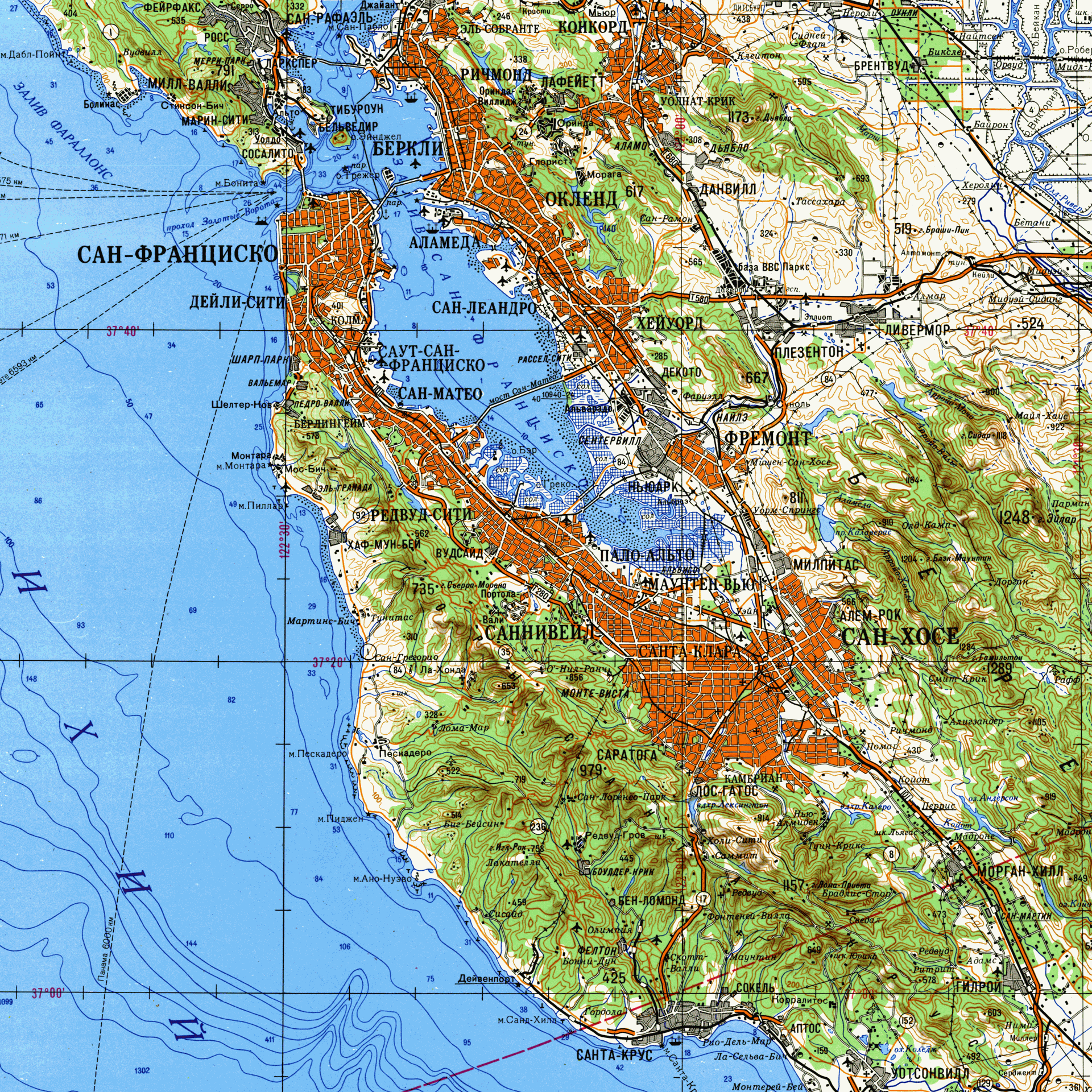
Soviet San Francisco
This Soviet rendition of San Francisco, published in 1980, paints a picture of the tensions between the United States and the Soviet Union, presenting a side of history often ignored by Americans. It was created by the Soviet government depicting the San Francisco Bay Area. Looking at the United States, a place so familiar to us, through the eyes of a non-American is so rare to those who have lived in the nation all their life. It is especially uncommon to look from the perspective of an enemy, such as that as the Soviet Union. San Francisco is almost undecipherable at a first glance. Without English guiding directing our attention to San Francisco, Alcatraz, The Golden Gate Bridge, San Jose, or any other part of this metropolitan area, one must evaluate the values of the author and translate them into a more familiar language.
Intentions of this map can only be assumed without the author revealing why he was commissioned to draft this piece. The 1980’s saw an end to the détente the two nations enjoyed throughout the 1970’s, reinstating hostilities after the Soviet invasion of Afghanistan. The unjustified invasion was the beginning of the end for the Soviet Union, helping to lead to its collapse in 1991. However, before they dissolved the socialist republic, they enjoyed a decade of volatility and aggression with the United States. The US elected a severely anti-Soviet president, Ronald Reagan, which prompted Soviet retaliation in the form of increased preparation for offensive and defensive measures. The Soviet Union could never conduct a full-scale invasion of the United States along the eastern coast because they would have to traverse Western Europe first to move supplies and troops. This would lead them instead to Alaska and the west coast as a means of ground invasion. Taking key cities along the west-coast (Los Angeles, San Diego, Portland, Seattle, and of course San Francisco) would be essential to securing a center of operations to move eastwards against the remaining defensive units. The Bay Area has been key to the United States technological innovations since the 1970’s and is a major port for international trade so cutting this region off would hinder US economic growth. These factors brought the Soviets attention to the Bay Area and prompted the need for a detailed recreation of this region.
The idea of “imagined geography” ties back into everything the Soviets did with the Bay Area in this map. Instead of projecting their domestic borders to present a mighty Soviet Union and describe their national pride in terms of geographic extensiveness, they mapped a part of another sovereign nation in their image. This map does not consume the city under the Iron Curtain, but rather implies the power, intentions, and capabilities of a nefarious Soviet Union. It tells the United States and its military if they wanted to, they could. This would quickly be disregarded by intelligence agencies in the United States as likely or even possible but would fester in the minds of America’s policy makers and the citizens. They would ask themselves “could they?” This was the very goal of the map, to impose onto the Bay Area Soviet values to construct a tool that could be used for an invasion, but more effectively and immediately be used for indoctrination and propaganda.
This detailed rendition of the Bay Area reveals Soviet values regarding the United States. The map presents the entrances and exits to this sprawling city, citing every harbor, airport, and freeway. This is what is important to the Soviets at a time like this, understanding the layout and having a guide to assist in quickly maneuvering the city. This would be as practical as it is fear inducing for Californians. Additionally, the map is overlaid with a very accurate topographical map showing the changes in elevation and navigable portions of the inner bay. The Soviets were devoted to developing a detailed map of the region for two reasons, neither of which would please American officials.
First of all, this map is noteworthy because it reflects a Soviet view. We have seen many Cold War era maps made by cartographers from the United States or its allies but we rarely see maps from the Soviet Union. Moreover, the political implication behind this map is very interesting. The Soviet Union conveyed the idea that they can use their technology and information to make detailed maps of U.S. cities. This was a demonstration of power and a warning. I think it is very similar to some of the Cold War maps we saw such as the Lunar Wall Mosaic. The United States showed its technology by making a map of the moon. Both the U.S. and the Soviet used maps to display their power and warn their enemies.
This map really hits home for me because I am from San Francisco, so to see a map that depicts San Francisco in a political perspective really encapsulates what our class has gone over for the semester. The Soviet Union displayed their technological and cartographical capabilities to warn the rest of the word of this notion of deteriorating privacy. With that being said, I thoroughly enjoyed your analysis of Soviet San Francisco.